Professor Zhang Peizhen’s team discovered the pulsed rise and growth of the Tibetan Plateau to its northern margin since ca. 30 Ma
Source: School of Earth Sciences and Engineering
Edited by: Zheng Longfei, Wang Dongmei
The formation of the Qaidam basin in the northeastern Tibet marked the onset of crustal deformation that propagated from the Indo-Asia collision zone to the northern margins of the Tibetan Plateau during the Cenozoic time. This paper presents magnetostratigraphies constrained by apatite fission-track ages that document the formation of the Qaidam basin at ca. 30 Ma, much younger than previous estimates of 65 to 50 Ma. Armed with chronology, the Qaidam basin–provenance analyses reveal pulsed deformation of the northeastern margin of the Tibetan Plateau beginning first at ca. 30 Ma and subsequently at ca. 10 Ma, timing suggesting close links to the removal of the mantle lithosphere beneath different portions of the Tibetan Plateau.
As the largest Cenozoic basin with >10-km–thick deposits in the northeastern Tibetan Plateau (14), the Qaidam basin’s inception, development, and extinction provides critical insights into the timing, processes, and mechanisms of Tibetan Plateau growth. Here, we combine detrital zircon provenance with magnetostratigraphies and detrital apatite fission-track (DAFT) from the Hongshan East and West sections in the northern basin margin (Fig. 1B) to decipher the inception of Cenozoic sedimentation in the Qaidam basin and the emergence of ranges around it.
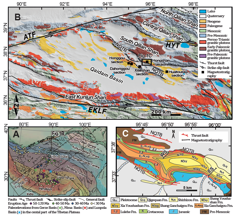
Figure 1: (A) Regional shaded relief map of the Tibetan Plateau showing major faults, terranes, volcanic rock ages, and paleoelevation study sites. (B) Generalized tectonic and topographic map of the East Kunlun Shan, Qilian Shan, and the Qaidam basin with magnetostratigraphic section locations (solid squares) in the north margin of the basin. (C) Geological map of the Hongshan region [modified after Qinghai Bureau of Geology and Mineral Resources.
Our sampled sections are referred to as the Hongshan West and the Hongshan East sections, which are exposed in the north and south flanks of a syncline, respectively, related to the NQTB (Fig. 1C). Based on magnetostratigraphies combined with detrital apatite fission-track ages, we date the basin fills to be from ca. 30 to 4.8 Ma (Fig. 2).
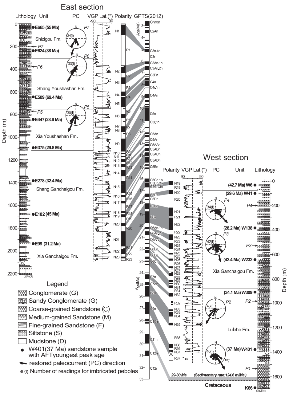
Figure 2: Correlations of observed magnetostratigraphy to the GPTS
The pulsed synchronous upward and outward growths of the Tibetan Plateau in both ca. 30 Ma and ca. 10 Ma call for a profound geological process to dictate the coeval plateau-wide uplift and associated borderland deformation. Many models have been proposed to interpret the geodynamic processes behind the growths of the Plateau but fail to account for temporal and spatial synchronicity of the coeval upward and outward growth. The only model that could explain it successfully is the convective removal of mantle lithosphere. Continental collision and subsequent convergence between the Indian and Eurasian continents significantly shorten and thicken Tibetan lithosphere, including both crust and mantle, which would cause Rayleigh–Taylor instability to erode the thickened mantle lithosphere and would eventually detach the thickened lithosphere to sink into the hot asthenospheric mantle. Buoyancy force associated with the dripping of mantle lithosphere would result in surface uplift to augment the potential energy and therefore to exert compressive stresses to the borderlands of the plateau causing synchronous and widespread deformation around the margins.
Tomographic results also show a fuzzy high seismic velocity body beneath the northern Tibet in the depth between 100 and 180 km, which could be interpreted as another piece of the removed mantle lithosphere. Rapid surface uplift and plateau-wide synchronous tectonic deformation (Fig. 5A) clearly suggest that this removed piece of the mantle lithosphere underneath the northern Tibet, together with the continuous sink of previous one, might have triggered upward and outward growth of the Tibetan Plateau since ca. 10 Ma (Fig. 5C). The coeval surface uplift and widespread deformation in the Qilian Shan probably are the consequence of this mantle lithospheric removal (Fig. 5C). We, therefore suggest that two-stage removal of thickened mantle lithosphere beneath different parts of the Tibetan Plateau drove the pulsed upward and outward growth of the Plateau to its recent margins since the late Paleogene.
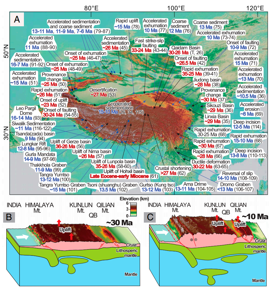
Figure 3: (A) Distribution of the major lines of evidence for ca. 30 and 10 Ma deformation/uplift in the Tibetan Plateau. (B) Schematic tectonic diagram illustrates the removal of mantle lithosphere beneath south and central Tibet driving plateau surface uplift and outward growth at ca. 30 Ma. (C) Following lithospheric thickening, convective instability triggers removal of lithospheric mantle beneath northern Tibet, causing the second-stage deformation and growth of the plateau to its recent northeastern margin in ca. 10 Ma.
The research article was recently published in Proceedings of the National Academy of Sciences of the United States of America.
Link to the paper: https://www.pnas.org/content/119/8/e2120364119